Antarctic Peninsula-Basecamp Plancius | Trip Itinerary
A Basecamp itinerary to the Antarctic Peninsula is illustrated below. All itineraries are for guidance only. Programs may vary depending on local ice and weather conditions, the availability of landing sites and opportunities to see wildlife. The final itinerary will be determined by the Expedition Leader on board. Flexibility is paramount for expedition cruises.
Go to: Additional Information on the Antarctic Peninsula
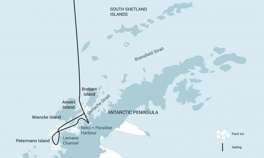
Map of Basecamp Plancius Route
Day 1 - End of the World; Start of your journey. Your voyage begins where the world drops off. Ushuaia, Argentina, reputed to be the southernmost city on the planet, is located on the far southern tip of South America. Starting in the afternoon, you embark from this small resort town on Tierra del Fuego, nicknamed “The End of the World,” and sail the mountain-fringed Beagle Channel for the remainder of the evening. . (D)
Days 2 & 3 - Path of the Polar Explorers. Over the next two days on the Drake Passage, you enjoy some of the same experiences encountered by the great polar explorers who first charted these regions: cool salt breezes, rolling seas, maybe even a fin whale spouting up sea spray. After passing the Antarctic Convergence – Antarctica’s natural boundary, formed when north-flowing cold waters collide with warmer sub-Antarctic seas – you are in the circum-Antarctic upwelling zone. Not only does the marine life change, the avian life changes too. Wandering albatrosses, grey-headed albatrosses, black-browed albatrosses, light-mantled sooty albatrosses, cape pigeons, southern fulmars, Wilson’s storm petrels, blue petrels, and Antarctic petrels are a few of the birds you might see. (B, L, D)
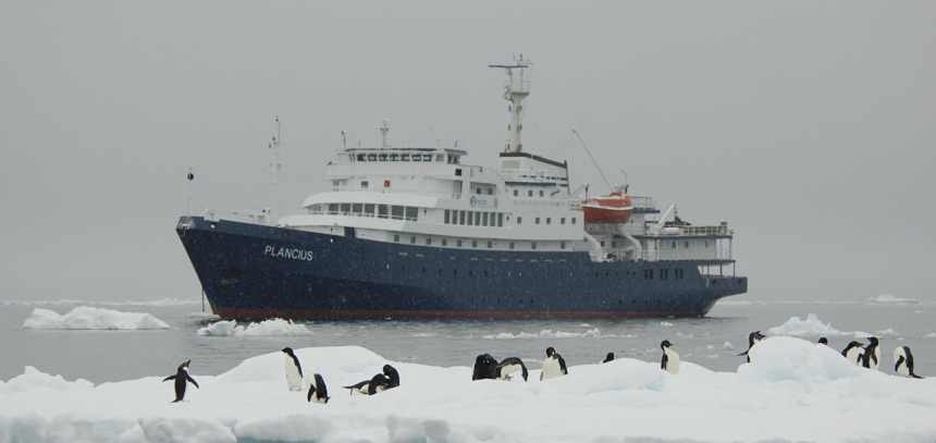
 Days 4 – 10 - Entering Antarctica. Gray stone peaks sketched with snow, towers of broken blue-white ice, and dramatically different wildlife below and above. You first pass the snow-capped Melchior Islands and Schollaert Channel, sailing between Brabant and Anvers Islands. Places you might visit include:
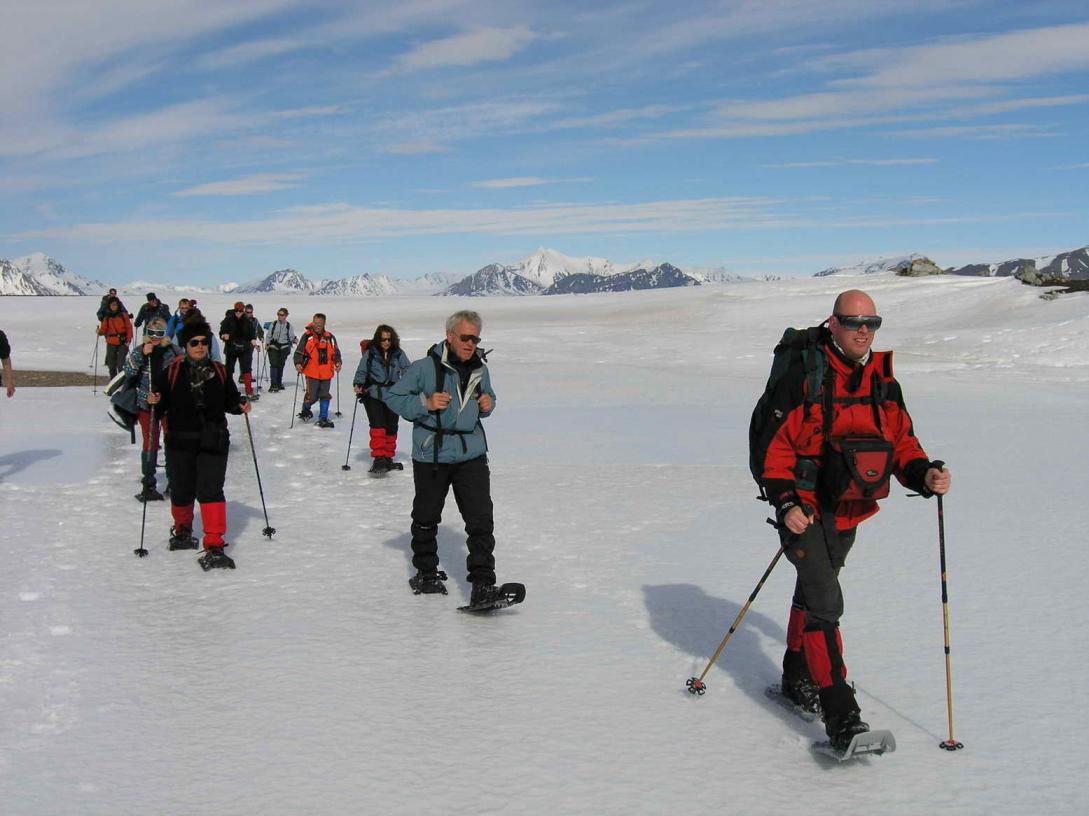
Neumayer Channel – The vessel may position itself here, launching its multiple basecamp activities from the protected waters around Wiencke Island. You can enjoy the splendors of this alpine environment at sea with Zodiac and kayaking trips, or if you’re in the mood for a walk, there are possible snowshoe hikes and soft-climb mountaineering options farther inland. Naturally, favorable weather conditions determine the possible activities.
Port Lockroy – After sailing through the Neumayer Channel, you may get a chance to visit the former British research station – now a museum and post office – of Port Lockroy on Goudier Island. You may also be able to partake in activities around Jougla Point, meeting gentoo penguins and blue-eyed shags. At the nearby sites, such as Damoy Point there may be the opportunity for snowshoeing to the old ski-way, this is also one of our favorite camping sites.
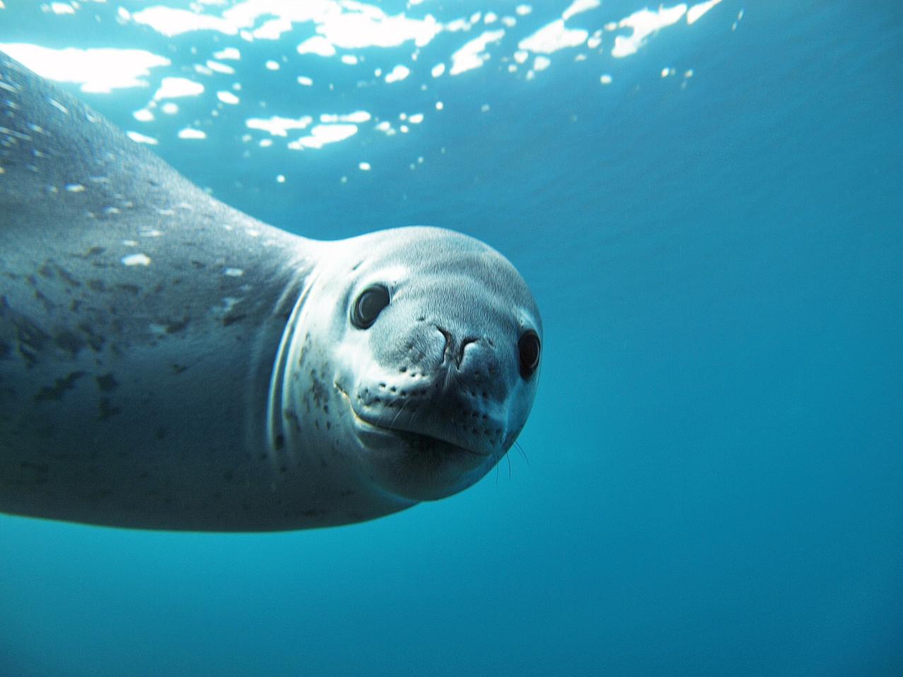 Pléneau & Petermann Islands – If the ice allows it, you can sail through the Lemaire Channel in search of Adélie penguins and blue-eyed shags. There’s also a good chance you’ll encounter humpback and minke whales here, as well as leopard seals. Kayaking, glacier walks, and more ambitious mountaineering trips are the potential activities of this location.
Neko Harbour – An epic landscape of mammoth glaciers and endless wind-carved snow, Neko Harbour offers opportunities for a Zodiac cruise and landing that afford the closest views of the surrounding alpine peaks.
Paradise Bay – You have the chance to make camp here like a true polar explorer, enjoying a supreme overnight Antarctic adventure.
Errera Channel – Possible sites in this area include Danco Island and Cuverville Island, but also the lesser known (though equally picturesque) Orne Island and Georges Point on Rongé Island.
On your last day of near-shore activities, you pass the Melchior Islands toward the open sea. Keep a sharp lookout for humpback whales in Dallmann Bay. You might also shoot for Half Moon Island, in the South Shetlands, with further chances for activities.
Conditions on the Drake Passage determine the exact time of departure. (B, L, D)
Days 11 & 12 - Your return voyage is far from lonely. While crossing the Drake, you’re again greeted by the vast array of seabirds remembered from the passage south. But they seem a little more familiar to you now, and you to them. (B, L, D)
Day 12 - We arrive in the morning and disembark in Ushuaia. (B)
B=Breakfast, L=Lunch, D=Dinner
Additional Information on the Antarctic Peninsula:
The Antarctic Peninsula is part of the Antarctic Continent and is the southern continuation of the mountain chain that runs from North America through South America into the Scotia Sea. Here it continues as a mainly sub-marine ridge, the Scotia Ridge, until it comes above sea-level at the northern tip of the Antarctic Peninsula. The peninsula consists of an 800 kilometres (500 mile) long mountain chain, the highest peaks rising to approximately 2,800 metres (9,186 feet), and numerous off-lying islands. The Peninsula offers the most dramatic scenery and biggest variety of wildlife in Antarctica. Visitors are easily overcome by sensory overload by the huge amount of ice-bergs, glaciers, high mountains and the abundant and tame wildlife.
The history of discovery runs parallel to that of the South Shetland Islands. Here, exploitation was again the major force behind the early explorations. Nowadays the Antarctic Peninsula is protected by the Antarctic Treaty, which has been signed by 46 countries. The signatory parties have agreed to abstain for 50 years from recognizing, disputing, or establishing territorial sovereignty claims. The parties also agreed to set aside Antarctica as a scientific preserve, established freedom of scientific investigation and banned military activity on the continent.
Climate
Antarctica can boast several records with relation to climate. It is the coldest, driest and windiest continent on earth. Although the Antarctic Peninsula is part of the continent it does not show these extremes. During the Austral summer temperatures as high as 15°C (59°F) have been recorded at the west side of the peninsula, however, the average temperature is around 2°C (36°F). Although blue skies and calm weather are common in the sheltered bays and channels, cold katabatic winds, caused by cold air accelerating under gravity from icecaps and glaciers, pick-up quickly and form a strong opponent for the Antarctic traveller.
Flora and Fauna
In the southern summer the large ice-free areas at the peninsula's north-west coast provide breeding grounds for large numbers of seabirds such as petrels, skuas and four species of penguins. On beaches and ice-flows nasty Fur Seals, sheepish Crabeater Seals, ferocious Leopard Seals and friendly Weddell Seals can be seen in abundance. In the waters around the Peninsula Fin Whales, Humpback Whales, Minke Whales and Killer Whales are common.
Vegetation is scarce on the peninsula though. Besides abundant lichens and mosses the only higher plants are Antarctic Hairgrass and Antarctic Pearlwort.
Map of Base Camp Plancius route:
Departures
Nov 11-23
Dec 22-Jan 3, 2022
Jan 3-15
Feb 24-Mar 8
Mar 8-20
Quads from $8500 pp
Twins from $10,450 pp
Superior from $12,300 pp